And now for a slightly different tour of old York – York as seen by a visiting artist.
In 1952 the curator of York Art Gallery – Hans Hess – approached L. S. Lowry to paint a scene of York for the annual Evelyn Award. For this Lowry would be awarded the princely sum of £50 or – in 2025 money – around £1,250.
In the end, Lowery was to paint three images of York; two he offered to the art gallery to select from – ‘Clifford’s Tower, York‘ and ‘A View of York (from Tang Hall Bridge)‘ – and a third – ‘Wilson’s Terrace‘ – that he sold on to a private collector.
Of the two images offered to York Art Gallery, they selected ‘Clifford’s Tower, York‘ which, as of writing, can currently be seen in one of the upper galleries.
‘Clifford’s Tower, York’
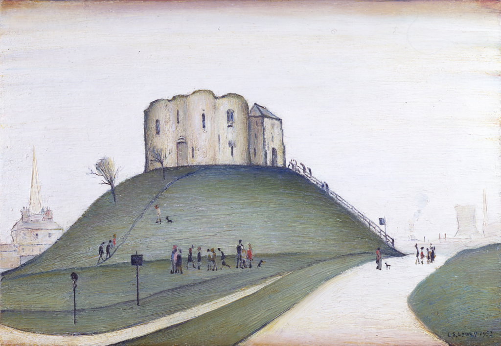
The most recognisable of Lowry paintings is his painting of Clifford’s Tower as seen from the corner of Tower Street and Crown Court access loop. Peeking over the left of the Tower’s mott is the church steeple and spire of York Saint Mary’s – a view now predominantly blocked by the bulk of the poorly aging York Hilton. To the right is the now lost Foss Islands power station cooling tower and the listed chimney of the York Council refuse destructor.
While this view of Clifford’s Tower feels like it is timeless, this view of Cliffords Tower and it’s mott is (at the time of painting) less than a generation old – prior to that both the tower and it’s mott would have been eclipsed by the hulking form of York Prison’s outer walls.
Today Google StreetView allows us a modern view from this point.
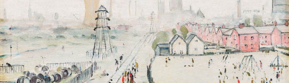
‘A View of York (from Tang Hall Bridge)’
While ‘Cliffords Tower, York‘ shows a classic view of York, one immortalised in thousands of pictures and photographs, ‘A View of York (from Tang Hall Bridge)‘ shows a part of York that the average tourist is unlikely to aim for – the bulk housing built at Tang Hall in the first half of the 20th century.
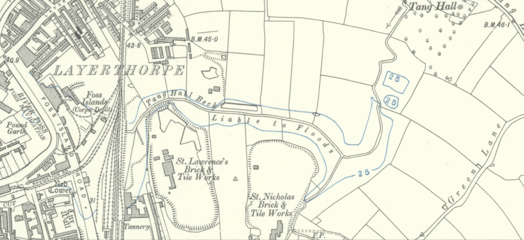
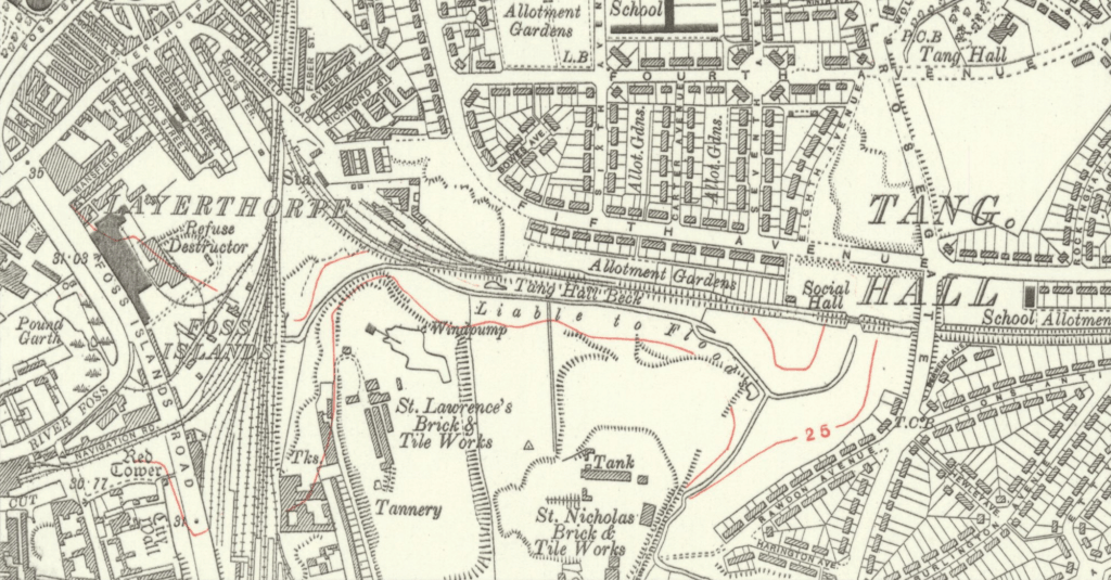
Tang Hall in 1907 – pre just about everything that makes Tang Hall Tang Hall. The bridge crossing the railway would be build to the right of the blue circled ’25’…
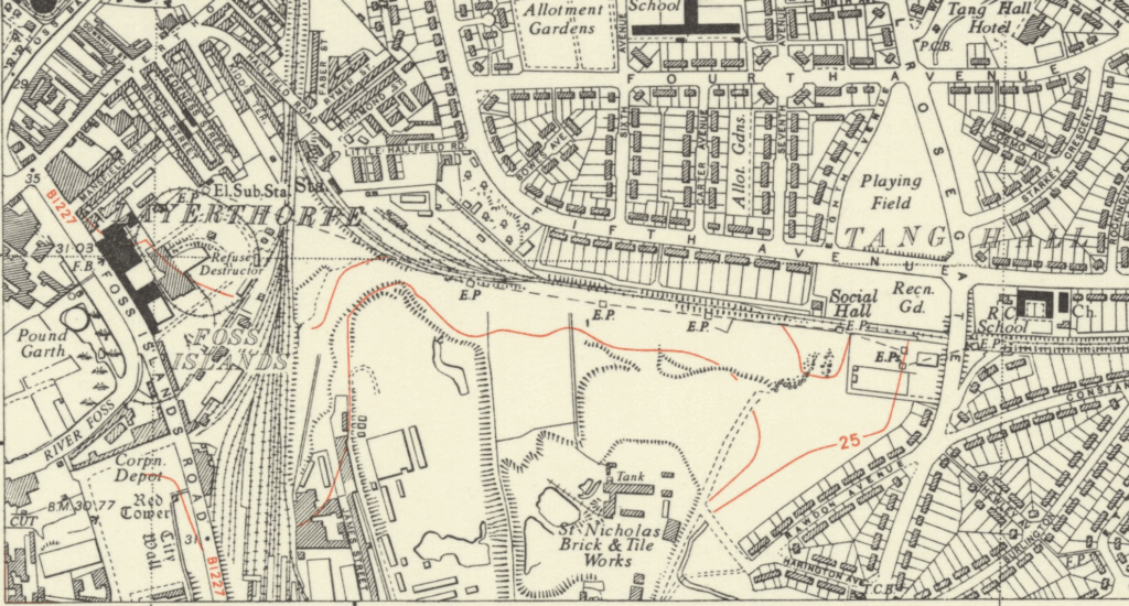
And jump forward to Tang Hall in 1929. Most of what Lowry painted has been built by his point – bridge, railway line, houses, and the Social Hall. The core exception to this is the electrical substation and Works to the left of the painting.
…and onwards to Tang Hall in 1950. The site is now complete with substation joining the houses and railway line previously constructed.
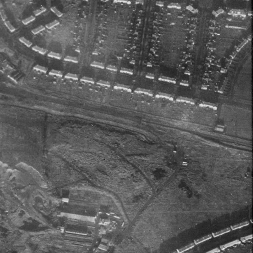
This crop of a 6th December, 1946 RAF areal photograph shows the recreation building in the centre-right and, just below the railway line, the faint outline of the electric compound. The scrubland to the left of the railway line is quite visible, this land would have been unattractive to build on due to the twin influences of the industrial site to the south and the presence of Tang Hall Beck which, until is was properly managed, would have left the area as a flood risk.
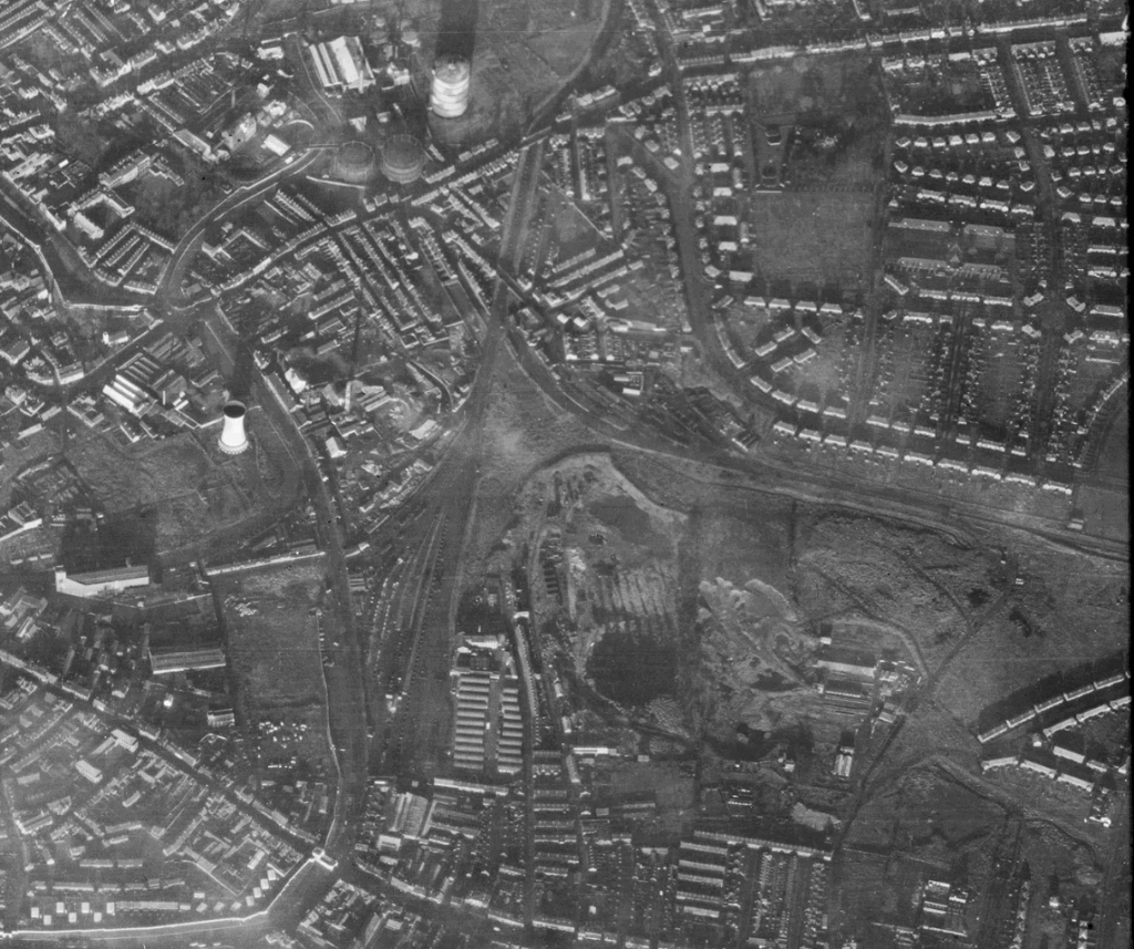
The same image – this time un-cropped – shows the large cooling tower that features behind the pylon (centre-right) , the gasometer (top-centre) and the chimney of the refuse distructor. Lowry, in this choice of location, has really left the traditional views of York for it’s industrial base and the labourers who would have manned it.
Through the centre of Lowry’s painting features the hazy shadow of York Minster, the horizon of this painting also features two more large smoke stack behind The Minster. The are likely to be the stacks of the now gone Sugar Beet works just off Boroughbridge Road.
Running through the centre of the painting is a singled-tracked railway line. This is the Derwent Valley Light Railway or ‘The Blackberry Line’, a not particularly successful single-tracked low traffic railway line that ran from Layerthorpe to Cliffe Common near Selby. Opened in 1912, ‘The Blackberry Line’ suffered the ignominy of being one of the few Standard Gauge lines not to be nationalised in the aftermath of the Second World War and, under it’s private owners, ran until it’s final closure in 1981.
Again, Google StreetView provides us with a modern view of this painting’s location.
‘Wilson’s Terrace’
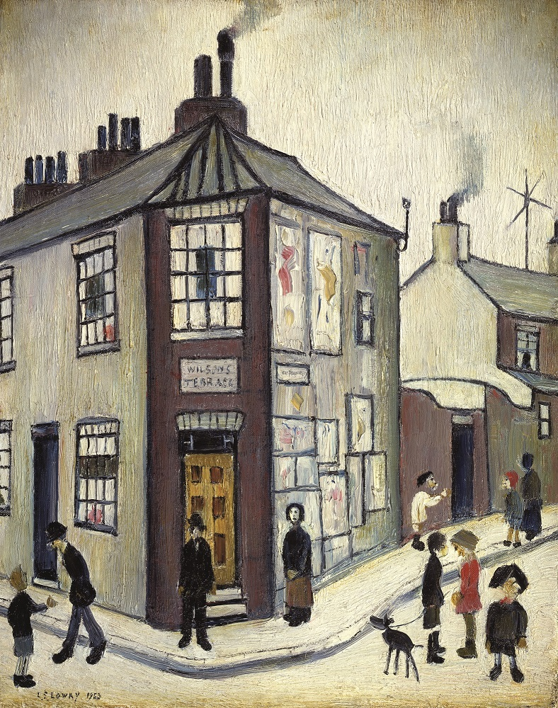
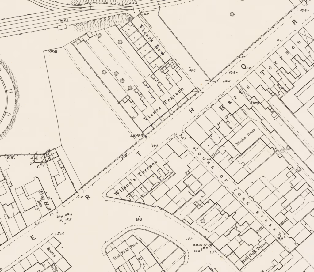
And onto the final painting of this series; ‘Wilson’s Terrace’. Now, while York has a good number of streets that end in Terrace (Avenue Terrace, Garth Terrace, Filey Terrace… to name but a few!), Wilson’s Terrace was not one of these. Facing north-west out onto Layerthorpe Road, Wilson’s Terrace was a row of terraced houses sandwiched between Hallfield Road and the now demolished Duke of York Street.
Of the three Lowry paintings, this is the site that has by far changed the most. Firstly, the load on Layerthorpe Road, always a main route into the city from the east, has massively increased as the city has spread east.

Secondly, that part of Layerthorpe Road is no-longer overshadowed by the massed bulk of gasometer’s that made up York Gas Works. This have now been demolished and a new road pushed across the former gasworks site.
Thirdly – and probably most importantly – the entirety of Wilson’s Terrace has been demolished with a middling middle-rise set of flat built on the location.
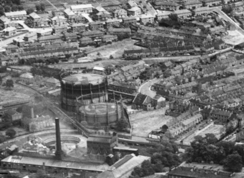
There don’t appear to be many photographs of Wilson’s Terrace from before it succumbed to the bulldozers, however the above photograph from Historic England shows Wilson Terrace just to the right of the upper gasometer. With that, Lowry’s painting of Wilson Terrace truly shows a lost part of York.